Project Summary:
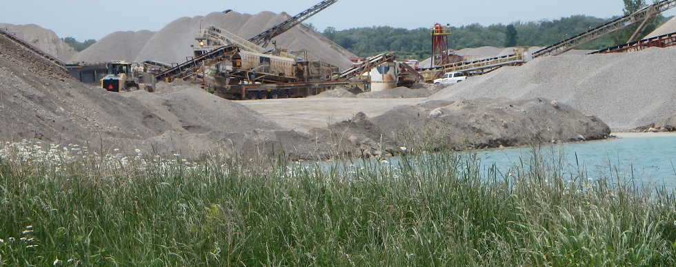
In November 2023, CBM Aggregates, a division of St Marys Cement Inc. (Canada), submitted an application for a new Class “A” licence (Pit Below Water) under the Aggregate Resources Act (ARA) on 6947 Concession Road 2, Township of Puslinch, Wellington County (the site) and applications under the Planning Act to the County of Wellington and the Township of Puslinch. The pit will be in close proximity to CBM’s Aberfoyle operations and will serve as a feeder pit to the existing processing plants.
In response to confusion, CBM Aggregates has decided to rename the Aberfoyle South Pit Expansion to the Aberfoyle South Lake Pit.

CBM initiated technical studies in 2018 to further evaluate the area, determine feasibility of a future application, and to assess potential effects of extraction. These studies, which include groundwater, surface water, natural environment, archaeology, and noise, and have been included as part of the application. CBM has also been engaging about this project with local and provincial governmental representatives and with Indigenous communities for a number of years.
The proposed extraction area is approximately 27.5 hectares (ha) in size. The maximum depth of extraction is expected to be approximately 20-25 metres (m) below the current ground surface to a lowest elevation of 285 metres above sea level (masl). Both above water table and below water table aggregate extraction will be completed at the pit. The raw aggregate will be temporarily stockpiled on-site and will then be processed at nearby CBM operations.
The proposed pit contains approximately 5.5 million tonnes of high-quality sand and gravel resources. CBM projects at this time that aggregate extraction will take place on the Aberfoyle South Expansion over a period of approximately 6 to 10 years, with a maximum annual aggregate extraction rate of 1 million tonnes per year. Site operations will not involve any pumping or active dewatering. The proposed pit operations will be limited to the daytime (7 am to 7 pm) period. Shipping hours will be restricted to 7 am to 6 pm on weekdays and 8 am to 4 pm on Saturdays.
The pit will be accessed via a new entrance located at the northeast end of the site. Trucks will ship extracted aggregate from the site along Concession 2 to the existing processing plant at the Aberfoyle South Pit, which is approximately 2 km to the east. Trucks will not be permitted to travel west on Concession 2 Road or use Sideroad 20 South.
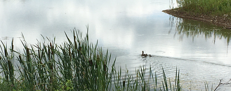
No extraction or disturbance is proposed in any portion of the adjacent Mill Creek Provincially Significant Wetland (PSW) and extraction will be setback a minimum of 30m from this feature. Potential impacts of the proposed pit on the PSW, Mill Creek and other significant natural features have been thoroughly examined through the technical studies undertaken with the application.
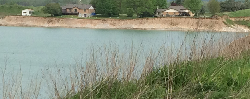
The removal of aggregate resources from below the water table will result in the creation of a lake that will be approximately 26 ha in size. Approximately 0.3 ha of new wetland habitat will be created in setbacks adjacent to the Mill Creek PSW. In addition, approximately 6.7 ha of new forest habitat will be created in setback areas. As required by the Aggregate Resources Act, rehabilitation must occur progressively as extraction proceeds through the site.
Updated Information (January 2026):
As a result of the comments received on the application, CBM and its project team have undertaken additional investigations and studies, and have proposed changes to the application in response to these comments. In summary, CBM has made the following key changes to the application:
- In response to confusion surrounding the name of the original proposal as a pit expansion, CBM has renamed the proposed pit “Aberfoyle South Lake Pit”. The application continues to be assessed as a new pit application under the ARA.
- Development of a Hydrological and Ecological Monitoring Plan to verify that no unanticipated adverse impact occurs to private wells and natural features, including trigger thresholds, and identifying potential corrective actions.
- Additional mitigation measures to protect adjacent natural features and surrounding lands including flood and groundwater uplift mitigation, enhanced visual screening and pit entrance improvements.
- Additional groundwater and surface water monitoring locations.
- Incorporation of a maximum disturbed area limiting how much of the site can be actively extracted or disturbed at any one time.
- Geotechnical requirements for haul route.
- Additional noise restrictions and conditions on pit operating equipment.
- Incorporation of specific rehabilitation targets and thresholds for tree planting areas, and an increase in the area of wetlands being created through pit rehabilitation.
Additional changes have been made to the application in response to comments which are outlined on the ARA Site Plan. The changes are identified in red-line.
As a result of the comments received, additional investigation and technical work have been undertaken including the following:
- Revised Transportation Impact Study, February 2025, TYLin
- Flood Mapping – Technical Memorandum, August 12, 2025, WSP
- Supplemental Assessment of Potential Impacts to Baseflow in Mill Creek and Tributary 3, October 21, 2025, WSP
- Supplemental Assessment of Potential Impacts to Provincially Significant Wetlands, October 21, 2025, WSP
- Supplemental Assessment and Mitigation of Post-Rehabilitation Groundwater Uplift, October 21, 2025, WSP
- Hydrological and Ecological Monitoring Plan, January 8, 2026, WSP
- Headwater Drainage Feature Assessment, October 22, 2025, WSP
- Revised Aggregate Resources Act Site Plan, January 2026, MHBC
- Visual Impact Assessment, March 2024, MHBC
Technical Report Summaries and Technical Report Downloads
The following technical studies and documentation were included as part of the ARA and Planning Act applications:
- Planning Report
- Site Plans
- Natural Environment Report (NER)
- Water Level 1 and Level 2 Assessment
- Maximum Predicted Water Table Report
- Noise Impact Assessment
- Stage 1, 2 & 3 Archaeological Assessments
- Agricultural Considerations Review
- Transportation Impact Study
- Aggregate Resource Evaluation
- Best Management Practices Plan for the Control of Fugitive Dust
The following provides a summary of the technical studies that were completed and a link to download the associated document if of interest.
Planning Report
A Planning Report was prepared to review and assess the proposed pit relative to provincial, Wellington County and Township of Puslinch land use planning policies and regulations. The Planning Report also includes a Summary Statement as required by the Aggregate Resources Act which outlines planning and land use considerations, agricultural classification of the site, source water protection considerations, the quality and quantity of aggregate resources, projected truck traffic, and the proposed progressive and final rehabilitation plans.
The site is designated Core Greenlands and Greenlands in the County’s Official Plan. The site is not located within the County’s Mineral Aggregate Resource Overlay (which are areas of high potential for aggregate extraction), but they contain high quality aggregate resources based on site-specific resource testing. The lands are zoned Natural Environment and Agricultural within the Township’s Environmental Protection Overlay. To permit extraction on the site, applications to amend the County’s Official Plan and Township Zoning By-law have been submitted. The Planning Report concluded that the proposed pit represents the wise use and management of provincially significant aggregate resources. The proposal is consistent with the Provincial Policy Statement, and conforms to the Growth Plan and the County’s Official Plan.
Download: Planning Report & ARA Summary Statement November 2023 (12.168 MB)
Site Plan
As required by the Aggregate Resources Act, a site plan has been prepared which identifies the existing features on and adjacent to the site, the operational requirements and conditions for the pit, and how the site will be progressively rehabilitated.
Download: ARA Site Plans November 2023 (7.484 MB)
Natural Environment Report
The purpose of the natural environment study is to assess potential environmental impacts of the proposed aggregate extraction on the site with respect to the environmental features and functions in the study area, the potential effects on the natural environment, and the rehabilitation potential of the site. The assessment was undertaken for potential ecological impacts under the ARA Provincial Standards, the Provincial Policy Statement, Growth Plan for the Greater Golden Horseshoe, policies of the County of Wellington, as well as other relevant legislation, including the Fisheries Act, the Migratory Bird Convention Act (MBCA) and the Endangered Species Act (ESA). The study area includes the site and surrounding 120 m boundary as defined in the Aggregate Resources of Ontario Provincial Standards, Section 2.2.
The investigation of existing conditions in the study area included a background information search and literature review to gather data about the local area and provide context for the evaluation of the natural features. An assessment was conducted to determine which species at risk (SAR) had potential habitat in the study area. The habitats and communities on the site were characterized through field surveys. The surveys were conducted from April to August 2018, in October 2021, and from March to September 2023 and involved plant community surveys and botanical inventory, anuran call count surveys, turtle habitat assessment, amphibian egg mass surveys, breeding bird surveys, bat surveys (habitat assessment and acoustic survey), fish and fish habitat surveys and visual encounter surveys. Wetland and woodland delineation was also completed at the site in June 2018 and August 2023, and again with representatives from the Grand River Conservation Authority and the Township of Puslinch on September 2023.
The results of the analysis completed as part of the study, potential temporary impacts to perennial fish habitat within Tributary #3 on site may occur as a result of the proposed extraction. Mitigation and permitting requirements will be confirmed through consultation with Fisheries and Oceans Canada (DFO) through the Request for Review process. No other impacts to the significant natural features and functions in the study area are expected. In addition, an ecologically based rehabilitation plan and preventive mitigation measures that will enhance the natural heritage system have been developed.
Download: Natural Environment Report November 2023 (12.747 MB)
Water Report Level 1 and 2
The purpose of the assessment is to characterize the existing hydrogeological and hydrological conditions in the vicinity of the site and how they relate to the surrounding natural environment, and to assess potential impacts, if any, that the proposed below-water extraction would have on surface water and groundwater in the area and identify need for mitigation. The assessment involved establishing baseline (current) surface water and groundwater conditions and completing an impact assessment considering proposed operational and rehabilitated site conditions. The completed tasks included a review of publicly available and relevant historic data, a field data collection program, and an assessment of the potential impact of the proposed below-water extraction on the surrounding groundwater and surface water receptors, including any creeks, streams, and nearby groundwater wells.
The proposed changes under operational and rehabilitated conditions are anticipated to result in minor, local groundwater level changes and increases to average annual surplus over the site footprint. The assessment concluded that:
- There will be a temporary reduction in localized (mostly within the site) groundwater levels during active aggregate extraction that may impact an overburden groundwater user within the predicted zone of influence of the site. Mitigation measures have been identified to address this impact. No impacts to this groundwater user are predicted during post-rehabilitation.
- With the implementation of applicable mitigation (e.g., CBM’s Best Management Practices, which include spill prevention and response), impacts to groundwater quality are not anticipated.
- Localized (mostly within the site) temporary reductions in baseflow during active aggregate extraction are anticipated. Baseflow changes are anticipated at Tributary #3 and Mill Creek.
- Upon post-rehabilitation, minor baseflow changes are anticipated at Tributary #3 and Mill Creek.
- The Mill Creek-Puslinch Provincially Significant Wetland (PSW) is predicted to have minor changes in groundwater discharge; however, with the implementation of best management practices and mitigation measures, no adverse impacts on the Mill Creek-Puslinch PSW are expected. No other natural receptors are predicted to experience a change in groundwater levels.
- A slight temperature increase is predicted at both Mill Creek and Tributary #3, but this is not expected to have a material impact on surface water receptors.
- No adverse impacts are predicted on the local surface water hydrology of Mill Creek or the Mill Creek-Puslinch PSW. The reduction in runoff from the site is predicted to have minor localized impacts to Tributary #3.
- Groundwater in the overburden and bedrock aquifers is not expected to be adversely impacted from a Source Water Protection perspective relative to current conditions.
- The post rehabilitated scenario represents an opportunity to generate improved water quality as a result of the change in land use from agriculture.
The assessment recommends that a private well survey be completed prior to the initiation of aggregate extraction, that CBM’s Best Management Practices and provincial standards for fuel handling be followed, and that groundwater monitoring be implemented throughout the operational period.
Download: Water Report Level 1&2 November 2023 (37.761 MB)
A maximum predicted water table report was also prepared as required by the ARA, which outlines how the maximum predicted water table was identified relative to the proposed depth of extraction at the pit:
Download: Maximum Predicted Water Table Report November 2023 (8.569 MB)
Noise Impact Assessment
WSP Canada Inc. (WSP) completed a Noise Impact Assessment for the site. WSP established sound level limits according to MECP noise guidelines and compared the predicted noise levels of at the identified representative Points of Reception (PORs) to the established limits. The results indicate that, after the implementation of identified noise controls or equivalent measures, the noise levels predicted at the off-site PORs are expected to be at or below the applicable noise limits. A change in noise levels along the haul route, during peak hauling hours, may be noticeable at times at the POR identified along the haul route, but it is not expected to be a significant change. Based on the results of the assessment, the site will operate in compliance with Ministry of Environment, Conservation and Parks and Ministry of Natural Resources and Forestry noise guidelines for all PORs.
Download: Noise Impact Assessment November 2023 (9.655 MB)
Stage 1 and Stage 2 Archaeological Assessment
A Stage 1 archaeological assessment was completed for the site. The Stage 1 assessment compiled available information about the known and potential archaeological resources within the study area and provided direction for the protection, management and/or recovery of these resources, consistent with the Ministry of Citizenship and Multiculturalism standards and guidelines. The Stage 1 assessment found potential for archaeological sites for pre-contact Indigenous and historical Euro-Canadian archaeological resources to exist within the study area and recommended further Stage 2 field surveys to further assess archaeological potential.
The objectives of the Stage 2 archaeological assessment were to provide an overview of archaeological resources within the study area and to determine whether any of the resources might be artifacts and archaeological sites with cultural heritage value or interest, and to provide direction for the protection, management and/or recovery of these resources. Areas recommended for Stage 2 assessment were surveyed by a combination of pedestrian and test pit surveys completed between June 26 and July 10, 2019. The Stage 2 survey involved participation by archaeological field liaisons from Mississauga of the Credit First Nation and Six Nations of the Grand River.
The Stage 2 archaeological assessment resulted in the identification of 25 locations and findspots with archaeological artifacts: 23 pre-contact Indigenous and two historical Euro-Canadian. Given the findings of the Stage 2 archaeological assessment, Stage 3 archaeological assessment was recommended for the historical Euro-Canadian component found at two of the locations. One of the locations had already been registered as an archaeological site with the MCM under Boden (AiHb-374). Stage 3 archaeological assessment is being completed at these two sites.
In addition, long-term protection an avoidance was recommended for one location related to Indigenous use of the area. This Indigenous location had also already been registered as an archaeological site with the MCM under Boden (AiHb-374). The protected area of this archaeological site is shown on the Site Plan accompanying the ARA licence application. CBM will adhere to the avoidance and protection measures outlined in the report and a licensed archaeologist will be present to conduct scheduled inspections and monitoring at the archeological site during and after construction.
No further archaeological assessment was recommended for the remaining locations or for the findspots identified.
The Stage 1-2 assessment and its findings were accepted by MCM.
Download: Stage 1 and 2 Archaeological Assessment August 2023 (10.103 MB)
Download: ENTERED INTO REGISTER Archaeological Report for P468-0054-2020 P468-0087-2022 (0.079 MB)
Download: Archaeologist CV_HahnRandy
Download: Archaeologist CV_FisherRhiannon
Stage 3 Archaeological Assessments
The Stage 3 archaeological assessments have been completed at the two sites identified in the Stage 2 assessment. The Stage 3 assessments determined that, prior to extraction, Stage 4 archaeological assessments are required. These areas have been identified on the Site Plans accompanying the ARA licence application in accordance with the recommendations of the Stage 1-2 and Stage 3 archaeological assessment reports.
Download: Stage 3 Archaeological Assessment Location 3 June 2023 (6.692 MB)
Download: Stage 3 Archaeological Assessment Location 5 June 2023 (5.653 MB)
Agricultural Considerations Review
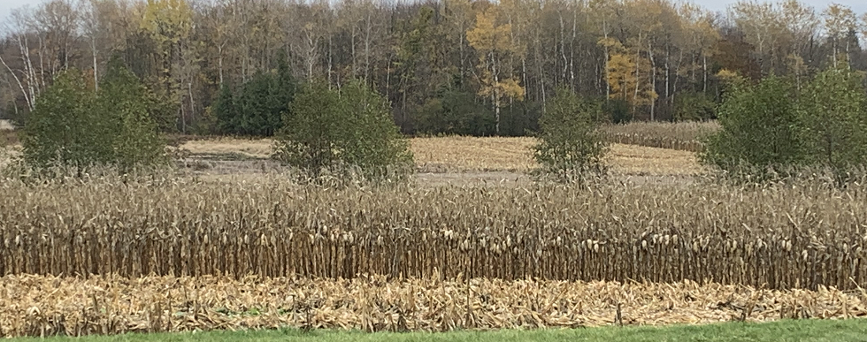
A small portion of identified Prime Agricultural Area (PAA) is identified on the west portion of the site and will be removed as part of the proposed pit expansion. Other identified PAA on the subject site is located outside of the limits of extraction and will not be removed. The proposed pit expansion is not anticipated to have negative impacts on the agricultural system in the area, subject to the implementation of recommended mitigation measures.
Download: Agricultural Considerations Review September 2023 (9.789 MB)
Transportation Impact Study
The Transportation Impact Study determined that the pit would generate a total of 28 truck trips during a peak hour (14 in, 14 out) which would travel 2km along Concession 2 from the pit to the Aberfoyle South Pit. The study concluded that nearby intersections are projected to operate with nearly zero delay and highly efficient conditions with the addition of future truck traffic. No operational roadway improvements, such as exclusive turn lanes at the site accesses, would be required to accommodate the projected pit traffic at the study intersections. A comprehensive test of the structural condition of the Mill Creek culvert and Concession 2 roadway was recommended to confirm the overall haul route’s load bearing capacity.
Download: Transportation Impact Study November 2023 (28.453 MB)
Aggregate Resource Evaluation Report
Based on on-site resource testing, it is estimated that there are approximately 5.5 million tonnes of sand and gravel resources available within the proposed extraction area for the Project.
Download: Aggregate Resource Evaluation November 2023 (23.244 MB)
Best Management Practices Plan for the Control of Fugitive Dust
A Best Management Practices Plan (BMPP) has been prepared to manage fugitive dust emissions associated with the Project. The BMPP will be reviewed periodically and updated, if required.
Download: BMPP for Control of Fugitive Dust October 2023 (2.148 MB)
May 2024 Virtual Public Information Session
CBM hosted a virtual public information session on May 8, 2024 from 6:00 to 8:00 p.m. to provide information to the public and answer questions related to the Aggregate Resources Act application for the Aberfoyle South Pit Expansion.
CBM would like to thank the neighbours and members of the Puslinch community that attended the virtual information session for your participation and for your questions and comments. The intent of the meeting was to provide an overview of the licence application and to answer your questions about the proposed project. We hope that we answered any questions that you may have at this stage and we look forward to continued dialogue with you as the licence application review process progresses.
A copy of the presentation provided at the meeting can be found at the link
The recording of the presentation can be watched below.
We welcome comments or questions you may have on the proposed project at any time and are committed to participating in constructive dialogue. If you would like to reach out to CBM, please contact us by phone or email:
Director of Lands, Resources and Environment
andreanne.simard@vcimentos.com
416-333-1459
Project Summary:
In November 2025, CBM Aggregates (CBM), a division of St Marys Cement Inc. (Canada), submitted an application for a Class “A” licence under the Aggregate Resources Act (ARA) for the proposed Safarik Pit, located at 4275 Concession Road 7, Township of Puslinch, Wellington County (the site). CBM also submitted applications under the Planning Act to the County of Wellington and the Township of Puslinch. Extraction at the Safarik Pit is proposed above and below the water table. The pit will be in close proximity to CBM’s Aberfoyle operations and will serve as a feeder pit to the existing processing plants.
CBM initiated technical studies in 2022 to further evaluate the area, determine the feasibility of an application, and to assess potential effects of extraction. These studies, which included groundwater, surface water, natural environment, archaeology, traffic, cultural heritage and noise, have been included as part of the applications.
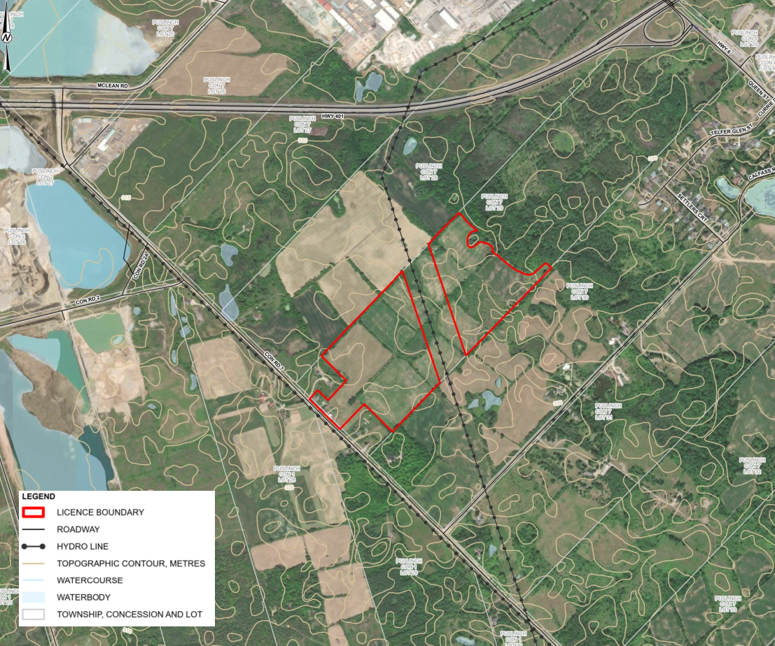
The proposed licensed area is made up of two areas separated by a Hydro Corridor (which is a separate land parcel). The area fronting onto Concession Road 7 and extending to the Hydro Corridor is referred to as Area B, and the portion to the east of the Hydro Corridor is referred to as Area A. Areas A and B have been named in relation to the proposed extraction phasing. Areas A and B are connected by a Right of Way Easement over the Hydro corridor, as shown on the ARA Site Plans. Overall, the subject lands are currently used for agricultural operations. Area B also contains a two-story farmhouse, garage, barn, and accessory structures proximal to Concession Road 7.
The proposed licence area is approximately 27.6 hectares (ha) with an extraction area of approximately 21.3 ha. The maximum depth of extraction is approximately 33.0 metres (m) below the current ground surface to a maximum depth of 295 metres above sea level (masl). Both above water table and below water table aggregate extraction will occur at the pit. The raw aggregate will be temporarily stockpiled within the extraction area of the site and will then be processed at nearby CBM operations.
The proposed pit contains approximately 5.0 million tonnes of high-quality sand and gravel resources. CBM anticipates that aggregate extraction will take place at the Safarik Pit over a period of 6 to 10 years, with a maximum annual aggregate extraction limit of 1 million tonnes per year. Site operations will not involve any water pumping or active dewatering. The proposed pit operations will be limited to the daytime (7 am to 7 pm) period. Shipping hours will be restricted to 7 am to 6 pm on weekdays and 8 am to 4 pm on Saturdays. Activities used to prepare the site for excavation, such as stripping of topsoil, construction of the berms, or activities related to the rehabilitation of the site after extraction is completed are considered to be construction activities and are only permitted to occur during the daytime from 7 am to 7 pm Monday to Friday.
The pit will be accessed via a new entrance/exit located on Concession Road 7, situated between the house and barn. Trucks will haul extracted aggregate from the site along Concession 7 to CBM’s main processing plant at the McNally Pit, which is approximately 1.4 km to the north. Trucks will not be permitted to travel south of the entrance on Concession Road 7.
No extraction or disturbance is proposed within any portion of the wetlands identified on or adjacent to the site. A 10 m setback from the extraction limit will be established adjacent to any wetlands. Potential impacts of the proposed pit on the wetlands have been thoroughly examined through technical studies undertaken with the application.
The removal of aggregate resources from below the water table will result in the creation of two ponds that will cover approximately 2.9 ha (in Area A) and 6.3 ha (in Area B). Approximately 0.1 ha of new wetland will be created along the northern limits of the Area A pond. Approximately 1.0 ha of new forest habitat will be created within setback areas. A pollinator plot area of approximately 0.6 ha will be developed in the southwest portion of Area A to improve the overall diversity of naturalized habitats on the landscape post-rehabilitation. As required by the Aggregate Resources Act, rehabilitation must occur progressively as extraction proceeds through the site.
Technical Report Summaries and Technical Report Downloads
The following technical studies and documentation were included as part of the ARA and Planning Act applications:
- Planning Report (MHBC Planning)
- Site Plans (MHBC Planning)
- Maximum Predicted Water Table Report (WSP Canada)
- Level 1 and 2 Water Report (WSP Canada)
- Natural Environment Report (WSP Canada)
- Stage 1 and 2 Archaeological Assessment (WSP Canada)
- Noise Assessment Report (WSP Canada)
- Cultural Heritage Impact Assessment (WSP Canada)
- Heritage Impact Assessment (WSP Canada)
- Traffic Impact Study (T.Y. Lin)
- Best Management Practices Plan for the Control of Fugitive Dust (WSP Canada)
The following provides a summary of the technical studies that were completed and a link to download the associated document if of interest.
Planning Report:
A Planning Report was prepared to review and assess the proposed pit relative to provincial, Wellington County and Township of Puslinch land use planning policies and regulations. The Planning Report also includes a Summary Statement as required by the Aggregate Resources Act which outlines planning and land use considerations, agricultural classification of the site, source water protection considerations, the quality and quantity of aggregate resources, projected truck traffic, and the proposed progressive and final rehabilitation plans.
The site is designated Secondary Agricultural, Core Greenlands, and Greenlands in the County’s Official Plan. The site is not located within the County’s Mineral Aggregate Resource Overlay (which are areas of high potential for aggregate extraction), but they contain high quality aggregate resources based on site-specific resource testing. The lands are zoned Agricultural and Natural Environment and are included within the Environmental Protection Overlay in the Township of Puslinch Zoning By-law. To permit extraction on the site, applications to amend the County’s Official Plan and Township Zoning By-law have been submitted. The Planning Report concluded that the proposed pit represents the wise use and management of provincially significant aggregate resources. The proposal is consistent with the Provincial Planning Statement and conforms to the County’s Official Plan.
An Agricultural Considerations Review was prepared as part of the Planning Report and included as Appendix A, to outline any potential impacts that the proposed pit may have on the agricultural system, and the agricultural operations in the surrounding area. The site is not located within a prime agricultural area as identified in the County’s Official Plan. The review concluded that the proposed pit is not anticipated to have negative impacts on the agricultural system in the area, subject to the implementation of recommended mitigation measures.
Download: Planning Report & ARA Summary Statement November 2025 (33.418 MB)
Site Plan:
As required by the Aggregate Resources Act, a site plan has been prepared which identifies the existing features on and adjacent to the site, the operational requirements and conditions for the pit, and how the site will be progressively rehabilitated.
Download: ARA Site Plans November 2025 (7.578 MB)
Natural Environment Report:
The purpose of the natural environment study is to assess potential environmental impacts of the proposed aggregate extraction on the site with respect to the environmental features and functions in the study area, the potential effects on the natural environment, and the rehabilitation potential of the site. The assessment was undertaken for potential ecological impacts under the ARA Provincial Standards, the Provincial Policy Statement, Growth Plan for the Greater Golden Horseshoe, policies of the County of Wellington, as well as other relevant legislation, including the Fisheries Act, the Migratory Bird Convention Act (MBCA) and the Endangered Species Act (ESA). The study area includes the site and surrounding 120 m boundary as defined in the Aggregate Resources of Ontario Provincial Standards, Section 2.2.
The investigation of existing conditions in the study area included a background information search and literature review to gather data about the local area and provide context for the evaluation of the natural features. An assessment was conducted to determine which species at risk (SAR) had potential habitat in the study area. The habitats and communities on the site were characterized through field surveys. The surveys were conducted from April to August 2018, in October 2021, and from March to September 2023 and involved plant community surveys and botanical inventory, anuran call count surveys, turtle habitat assessment, amphibian egg mass surveys, breeding bird surveys, bat surveys (habitat assessment and acoustic survey), fish and fish habitat surveys and visual encounter surveys. Wetland and woodland delineation was also completed at the site in June 2018 and August 2023, and again with representatives from the Grand River Conservation Authority and the Township of Puslinch on September 2023.
The results of the analysis completed as part of the study, potential temporary impacts to perennial fish habitat within Tributary #3 on site may occur as a result of the proposed extraction. Mitigation and permitting requirements will be confirmed through consultation with Fisheries and Oceans Canada (DFO) through the Request for Review process. No other impacts to the significant natural features and functions in the study area are expected. In addition, an ecologically based rehabilitation plan and preventive mitigation measures that will enhance the natural heritage system have been developed.
Download: Natural Environment Report September 2025 (19.843 MB)
Level 1 and 2 Water Report:
The Level 1 and 2 Water Report characterizes the existing hydrogeological and hydrological conditions in the vicinity of the site and how they relate to the surrounding natural environment. It also assesses potential impacts that the proposed below-water extraction would have on surface water and groundwater in the area and recommends the appropriate mitigation measures. The Water Report work program included a review of published hydrogeological studies and available water monitoring data to assess the local geology, hydrogeology and hydrology and to identify gaps in the conceptual understanding of the Site. A drilling program was conducted at the Site to improve the understanding of the local geology, as well as to establish a groundwater monitoring well network. Hydraulic testing, groundwater quality sampling, groundwater level monitoring and surface water monitoring were also completed to characterize baseline water conditions.
The report identified several existing aggregate pits that are in close proximity to the Site, and that detailed monitoring programs in place for these existing pits indicates that adverse impacts to local groundwater users and surface water resources have not been observed. The report concludes that unevaluated wetlands mapped on and near the Site are not interpreted to be hydraulically connected to the regional water table. The report identified several water wells present near the subject lands, with the majority of the wells being installed into the bedrock underlying the sand and gravel resource. The report concluded that no adverse impacts to off-site well users are predicted.
To mitigate the impacts of the proposed Safarik Pit, the Water Report recommended the following should be implemented upon licence approval:
- A proactive and long-term groundwater and surface water monitoring program will be completed during the pit operational and rehabilitation phases, until the licence is surrendered;
- A well interference and mitigation plan will be implemented proactively prior to pit operation; and
- A spill action plan will be developed and administered throughout all phases of pit operations.
Download: Water Report Level 1&2 October 2025 (29.574 MB)
Maximum Predicted Water Table Report:
A maximum predicted water table report was also prepared as required by the ARA, which outlines how the maximum predicted water table was identified relative to the proposed depth of extraction at the pit.
Download: Maximum Predicted Water Table Report October 2025 (2.403 MB)
Noise Assessment Report:
Sound level limits have been established according to the Ministry of Environment, Conservation and Parks (MECP) noise guidelines and compared the predicted noise levels of at the identified representative Points of Reception (PORs) to the established limits. The results indicate that, after the implementation of identified noise controls or equivalent measures, the noise levels predicted at the off-site PORs are expected to be at or below the applicable noise limits. Based on the results of the assessment, the site will operate in compliance with MECP and Ministry of Natural Resources (MNR) noise guidelines for all PORs.
Download: Noise Assessment Report November 2025 (17.641 MB)
Stage 1 and Stage 2 Archaeological Assessment:
A Stage 1 and 2 archeological assessment identified four archaeological sites within the proposed licence area. One of these sites (Location 1) consisted of historic Euro-Canadian artifacts and faunal elements representative of a mid-late 19th century historical homestead, and was considered to have further cultural heritage value or interest for which was recommended a Stage 3 archaeological assessment be conducted. The other three sites (i.e., Locations 2, 3 & 4) did not meet the criteria within the standards set by the Ministry of Citizenship and Multiculturalism (MCM) and were not considered to have further cultural heritage value or interest; as such, further assessment was not recommended for these sites.
The recommended Stage 3 archaeological assessment will be conducted in advance of the approval of the Safarik Pit.
The Stage 1 and 2 Archaeological Assessment Report and its findings are currently under review by the MCM.
Traffic Impact Study:
The Transportation Impact Study determined that the pit would generate a total of 28 truck trips during the AM and PM peak hours (14 in, 14 out) which would travel 1.4 km north along Concession Road 7 from the proposed pit to the CBM McNally Pit for material processing. The study concluded that existing transportation infrastructure can accommodate the projected increase in traffic resulting from the proposed Safarik Pit’s operation. The report also concluded that both current and future traffic conditions, including the added site-generated traffic, will not result in significant impacts on the surrounding road network and proposed haul route.
Download: Traffic Impact Study August 2025 (25.229 MB)
Best Management Practices Plan for the Control of Fugitive Dust:
A Best Management Practices Plan (BMPP) has been prepared to manage fugitive dust emissions associated with the proposed Safarik Pit. The BMPP will be reviewed periodically and updated, if required.
Download: BMPP for Control of Fugitive Dust October 2025 (23.244 MB)
Public Information Sessions
CBM will be hosting a public information session in the future as this ARA licence application is considered. Meeting details will be circulated when confirmed and we encourage community members to attend to learn more about the proposed project and ask any questions.
Material following the information session will be posted here.
We welcome comments or questions you may have on the proposed project at any time and are committed to participating in constructive dialogue. If you would like to reach out to CBM, please contact us by phone or email:
Director of Lands, Resources and Environment
andreanne.simard@vcimentos.com
416-333-1459